


About Walkwyse
Walkwyse Ltd is a not for profit company, set up by Lin & Peter Horne, which is responsible for the development and support of the Walkwyse outside activity Web App and its aim of raising funds for Alzheimer's Research UK.

There are many outdoor activities available for “serious” walkers or joggers and those who go to event driven activities such as marathons or other large outside activity fund raising events. Walkwyse is designed to encourage those people who don’t exercise very often to take an outside walk, either individually or as a family, and have fun whilst improving their health and mental wellbeing.
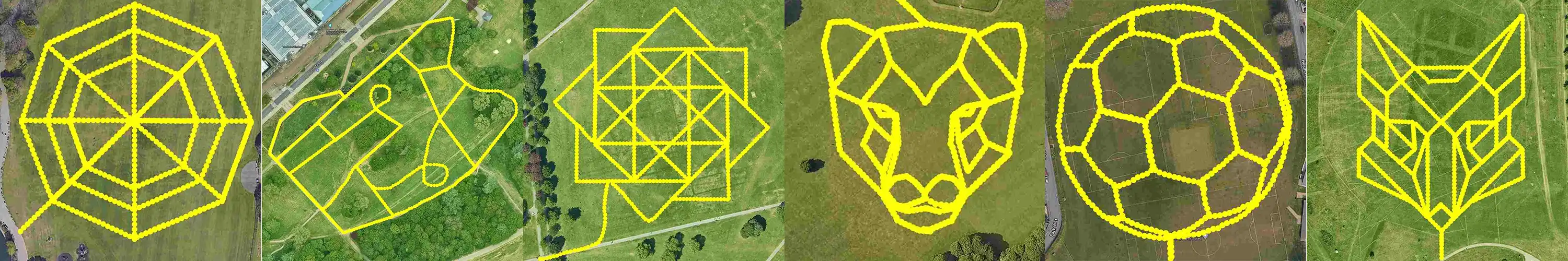
Walkwyse aMazing trails are a pirate themed virtual maze game located in public parks and vary in length from less than 1km to 20km. We place the aMazing trails in public parks to make them as accessible and as easy walking as possible.
We ask people who take part in our aMazing trails to make a donation to Alzheimer’s Research UK if they enjoyed the experience.
Outside activity is extremely important to people with dementia often lifting their “spirit” once they start walking as well as having the normal health benefits. Although it is not designed for people with advanced dementia it certainly can help but would necessitate that they are led by a carer.
aMazing trails have a competitive element where participants attempt to achieve the highest score by completing the maze in the shortest time & distance whilst collecting virtual treasure. Great fun for all the family!
to Alzheimer's Research UK
via our Just Giving page.
In 2019 Lin was diagnosed with the devastating desease of Alzheimer’s, but we were determined to keep doing our favourite activities as long as possible. The one thing she enjoys the most is walking, as does Peter, and it is great for health and wellbeing So creating an outside activity Web App for families, which anyone with a smart phone can access, seemed a great thing to do as a means of raising money for Alzheimer's Research.
Lin & Peter are also virtually "Rambling across Europe", a 10,800km walk, as a means of raising money for Alzheimer's Research and reached Rome at Xmas 2023 having taken 2 years to walk the 2,400km from Dartmouth to Rome. You can follow them on their Facebook, Instagram, X and TikTok feeds, just search for 'WalkwyseUK' on Facebook and 'Walkwyse' on Instagram, X and TikTok.
As a technologist Peter has always been interested in how technology can be applied to every day life. Having trained as a volunteer guide at the National Arboretum at Westonbirt in 2018, he was well versed in leading walkers around a trail and providing them with fascinating facts about nature and history. During Covid lockdowns (when guiding was not possible at Westonbirt) he set about the challenge of converting this knowledge into brief audio/visual stories which could be GPS triggered at relevant locations around a walk with a Web App. Thus Walkwyse was born!
Lin & Peter are determined that the results of their fund raising effort is focused on research to find a cure for the devastating diseases that cause dementia and believe Alzheimer's Research UK is the best organisation to make this happen.
Contact us: support@walkwyse.com
"aMazing trails: a fun outside virtual maze game requiring skill and a smart phone"
- The survey prize draw runs between March 10th and May 8th.
- All completed form submitted during the month will be entered into the draw.
- The first FIVE randomly drawn completed surveys on May 9th will be emailed a £50 Amazon voucher.
- The Amazon voucher will be emailed to the winner of the draw using the email address they entered on the form.
- Only one prize can be won by a user, a user is defined by the email address they entered on the form.
For Fun, Health & Wellbeing
aMazing Trails
aMazing trails are a new type of outdoor activity - a pirate themed virtual maze game - which you solve using the GPS and compass features on your mobile device. The virtual mazes are located in hundreds of public parks across the UK.
Sign up to participate and try one of our fun aMazing trails which vary in length from 1km to 20km!. The Web App is FREE, our only request is if you enjoy the maze, please make a donation to Alzheimer's Research.
Hyde Park & Kensington Gardens
The NEW 10km & 20km aMazing trail challenges consists of extremely long mazes for long distance walkers or joggers, these are the longest mazes in the World!
In the guiness book of records the current longest maze is Yancheng Dafeng Dream Maze (in China) which is 9km long.
We currently only have two of these challenge trails as it requires a very large, well maintained public park, to create a maze suitable for people with a range of abilities.
These aMazing trails are great for individuals or groups who wish to use them as their personal challenge to raise money for Alzheimer's Research.
Talk & Look Like a Pirate!
Have some fun creating your own pirate look & voice! with our simple to use pirate filter-effects facility.
Try on Pirate hats and beards, lip sink with one of the pirate voices, have pirates dancing on a desert island in the background
The facility, which works best on a mobile device, can take a couple of minutes to load, dependant on your Internet speed.
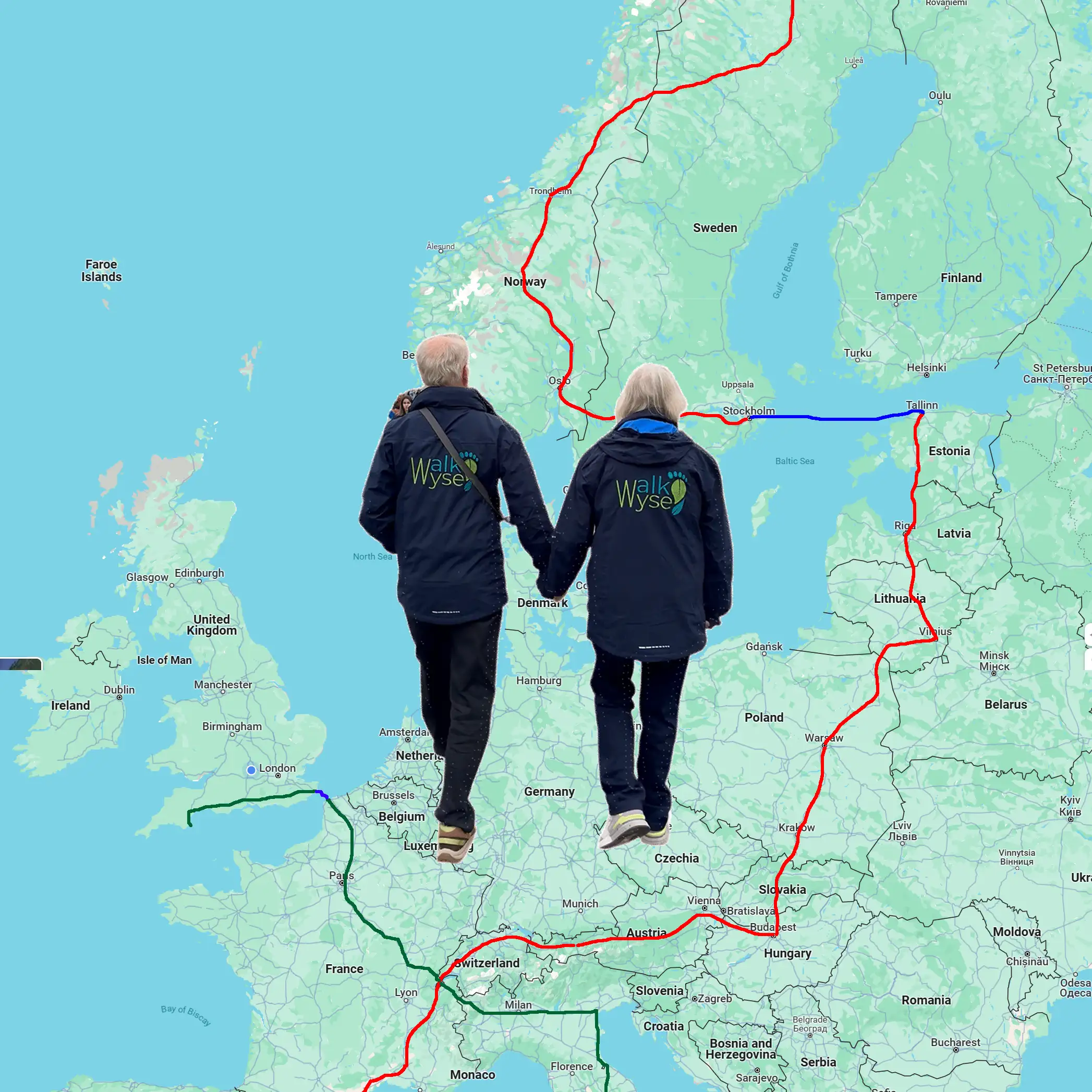
10,800km Ramble Across Europe
Release date in late May
An exciting virtual "Ramble Across Europe" update to this web app will be released at the end of May. Lin (age 71) and Peter (age 72) have been walking for the last 2 years and reached Rome in late December 2023, 2,400km from where they live in the UK.
They are now walking their way down the 'leg of Italy', from Rome to Messina (a distance of 727km), and are looking for anyone who wishes to virtually join them on their journey to help raise money for Alzheimer's Research.
position in Italy
You don't have to walk the remaining huge distance of over 8,000km,as you can participate on 'equal terms' whether you want to walk 5km/week or 30km/week. You can also choose to particpate for a specific stage(s) or all the way! Our handicap system allows everyone to reach various points along the route at the same time.
The next stage of the ramble will be from Gibralta to Seville, a distance of 184km, and will begin in early July.
The end of this enormous walking challenge is Narvik, Norway, which Lin & Peter hope to reach in 2029!
to Alzheimer's Research UK
via our Just Giving page.
The Walkwyse Ramble Across Europe challenge, is a charity walk like no other! It is not an event, it lasts for as long as you wish to participate. You don't have to travel anywhere to participate, you can just go outside your front door and walk. The distance you actually walk is under your control, and it is up to you to set how hard you want your challenge to be.
Lin (age 71) and Peter (age 72) have been walking for the last 2 years, averaging about 23km/week, and reached Rome in late December 2023, this is 2,400km from where they live in the UK. This year they have increased their distance per week to just under 30km and are walking their way down the 'leg of Italy'. They are looking for anyone who wishes to virtually join them on their journey and help raise money for Alzheimer's Research UK.
The end of their challenge journey is Narvik, Norway, which they hope to reach during 2029!
You don't need to physically walk across Europe, you walk where you live on your favourite rambles. You record these outside walks using the Walkwyse web app, you can see your walk displayed on a map when you have completed each walk. You can also see where you are on a map of the virtual Ramble Across Europe.
This is not a competitive challenge, there are no prizes for reaching the end of a stage or the end of the complete ramble first. Speed & distance are linked to the progress of Lin & Peter. It is however important that you set the distance that you believe you can walk each week to be a personal challenge, neither too high nor too low.
In order to enable people who can only walk 5km/week to keep up with those who wish to walk 60km/week there is a handicap system. This allows everyone to reach various points along the route at the same time. The distance Lin & Peter walk (30km/week) is used as the 'target' distance to which other distances will be adjusted. Both your actual distance and your adjusted distance will be recorded by the app.
- For instance if you choose a target of 5km per week any distance you walk will be adjusted up by a factor of 6,
- whilst if you choose a target of 60km/week the distance will be adjusted down by a factor of 2.
This web app is not particularly intended for people wanting to jog or run, however, you are welcome to participate in this challenge. Cycling is not supported.
- Normal walking speed is less than 7km/hour, jogging and running are typically less that 16km/hour.
- Any 'ramble' where a speed of over 16km/hour is recorded will be discarded.
You can choose to participate in just one stage of the ramble, if you don't know how long you can, or want to be involved. You can always take part in additional stages at a later time. Stages begin when Lin and Peter reach the stage start location, so some stages won't start for a few years yet!
You can join a stage as long as there is more than 120km remaining, that is Lin & Peter are at least 120km from the end of that stage.
You can use your own Just Giving page to raise money for Alzheimer's Research or use the Walkwyse JustGiving page where 100% of the money goes to Alzheimer's Research UK.
Before you can start using the Ramble Across Europe software you must complete and submit the Challenge details form.
The only cost is on joining up when we require you to donate £5 to Alzheimer's Research, via our JustGiving page. Make this donation after you have submitted the Challenge details form. Please enter the JustGiving code, displayed on the challenge form, next to your name on the JustGiving page in order that we can link the donation to your sign-in details.
request

Before loading the trail we need to check that your mobile device has all the features required to run the Web App successfully. Click the button to run the tests.
services (GPS)
software
Sensors
Sensors